Hochvogel peak in Europe under control
Anticipate the risk is fundamental for HAPPY MONITORING.
We are an expert team in real-time 3D monitoring, and we help governments and companies to prevent accidents. The HAPPY MONITORING system allows users to calculate the coordinates of the measured point regardless of the GNSS system (GPS and/or GLONASS and/or GALILEO and/or BEIDOU).
HAPPY MONITORING implementation – Hochvogel peak – Archives: HAPPY MONITORING
The data thus collected is automatically stored on a server in Switzerland or on the territory of the monitoring. This information can be consulted on the Internet in a personal space ordered by an XLM request. An application allows you to view the results in real time and create an interactive report with the summary of the measurements in graphical form. No scientific software is needed for calculation.
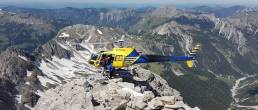
Anticipating risk is fundamental for us. In partnership with the Technical University of Munich, our team is monitoring the volatile “Hochvogel” peak.
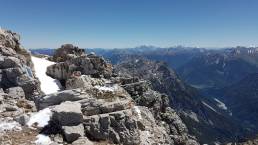
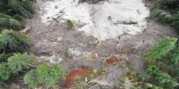
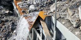
“Hochvogel”, perched at 2592m, is a peak in the Allgäu Alps that is threatening to separate, and its 260,000 cubic meters of rock and rubble could fall into the valley. The national border between Germany and Austria passes over the summit, but the southern summit area is in danger of collapsing, “it’s only a matter of time,” according to Professor Michael Krautblatter of the University.

HAPPY MONITORING, partner of AlpSenseRely
HAPPY MONITORING is one of the collaborative partners of a reference study developed by the Technical University of Munich, AlpSenseRely which is a three-year reference study in four Alpine regions (Bavaria, Tyrol, Salzburg, and South Tyrol) focused on the reliability and potential of high availability early warning systems for remote sensing of natural hazards in Alpine areas particularly sensitive to climate change. The objective is to make an important contribution to risk reduction and due to its preventive character, to the reduction of costs of climate-related natural hazards. AlpSenseRely is focused on the anticipation of risks and alert processes in the working environment of infrastructures in real time.
https://www.bgu.tum.de/en/landslides/alpsense/projekt/
HAPPY MONITORING has already been used on the Hochvogel since October 2020. So far it has proven to be very reliable and can deliver excellent results despite the many difficult circumstances: on the one hand, the altitude difference between base (in the valley) and rovers of almost 1500m with a baseline length of <5km and on the other hand the climatically unfavorable situation on the mountain (thunderstorms, temperatures).
Related Posts
See what matters, before it’s too late
HAPPY MONITORING at 19th Geotechnics Day: sharing insights on natural hazard prevention and smart monitoring in Innsbruck.
HAPPY MONITORING is Leading the Way at Tiroler Geotechniktag 2025
We’re proud to announce that HAPPY MONITORING will have its own stand at the 19th Tiroler Geotechniktag – Naturgefahren, Austria’s key conference on natural hazard mitigation and…

Roya International and HAPPY MONITORING: Pioneering Real-Time Infrastructure Safety
We, as HAPPY SURVEY and HAPPY MONITORING, were part of the worldwide geo-community at INTERGEO 2023 in Berlin. That world's largest event and communication platform in the field…