HAPPY MONITORING a Swiss development company that has developed a GNSS system for millimetre-accurate real-time monitoring.
Lugano, 9 February – HAPPY MONITORING is a Swiss development expert in real-time 3D monitoring. The company represents the most modern and innovative solution dedicated to monitor any possible movements in natural landscapes – such as volcanoes and mountains – or artificial structures – such as dams, bridges, railways, mining or building sites. Our system allows users to calculate the coordinates of the measured point regardless of the GNSS system (GPS and/or GLONASS and/or GALILEO and/or BEIDOU). The data thus collected is automatically stored on a server in Switzerland or on the territory of the monitoring.
Using a simple request (XML or JSON), the unique algorithm developed by HAPPY MONITORING, automatically calculates the results without any kind of user post-processing. An application allows you to view the results in real time and create an interactive report with the summary of the measurements in graphical form.
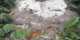
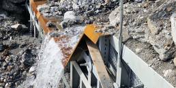
A concrete example of monitoring in the Allgäu Alps in Germany
Anticipating risk is fundamental for us. In partnership with the Technical University of Munich, our team is monitoring the volatile “Hochvogel” peak.
“Hochvogel”, perched at 2592m, is a peak in the Allgäu Alps that is threatening to separate, and its 260,000 cubic meters of rock and rubble could fall into the valley. The national border between Germany and Austria passes over the summit, but the southern summit area is in danger of collapsing, “it’s only a matter of time,” according to Professor Michael Krautblatter of the University.
HAPPY MONITORING has already been used on the Hochvogel since October 2020. So far it has proven to be very reliable and can deliver excellent results despite the many difficult circumstances: on the one hand, the altitude difference between base (in the valley) and rovers of almost 1500m with a baseline length of <5km and on the other hand the climatically unfavorable situation on the mountain (thunderstorms, temperatures).
Discover HAPPY MONITORING in two minutes
HAPPY MONITORING innovative solution is dedicated to monitor in real time any possible movement in natural landscapes or artificial structures. In order to better understand our expertise in high-precision and unique measurement of millimeters without any visibility on the movement, click and be HAPPY!

Vertical and horizontal millimeter measurements
HAPPY MONITORING develops two solutions, adapted for each infrastructure and landslide.
HAPPY HAWK, the power of vision
HAPPY HAWK is the best GNSS monitoring-system on the market. It is the high precision real-time monitoring system ideal for the most extreme weather conditions.
It is equipped with a multi-frequency receiver with integrated GPRS and can use corrections from VRS and HAPPY BASE for maximum accuracy. In only 24h it is possible to get 1mm horizontal accuracy and 2mm vertical accuracy.
HAPPY EIDER, small and light for high accuracy
HAPPY EIDER is a lightweight and compact real-time monitoring system that can be installed in a minute. It is suitable for emergency monitoring due to the possibility of installing an alarm. It is of course a cloud-based system that can work via 230V or photovoltaic panels. It is equipped with a multi-frequency receiver and external hotspot and can use corrections from VRS and HAPPY BASE for maximum accuracy. In only 24h it is possible to get 1,5mm horizontal accuracy and 2,5mm vertical accuracy. (Baseline < 3km/24h).
HAPPY MONITORING moves to the cloud
HAPPY MONITORING has decided to migrate all servers on local cloud servers in the destinated countries to improve its performances and the global user experience of its customers. Apart from the scalability of the system, costs, the company allows its users to access the cloud services and data in local EPSG*) in the cloud. As a result, the integrity of data in the cloud offers much greater security and flexibility.
“We are very pleased to announce to our customers that they can now get all of their secure data on a local server,” said René Schnider, Sales and Technical Director. “For a young company like ours, this is an important migration because we want to create added value for our customers”.
* the local coordinate systems worldwide
Related Posts
See what matters, before it’s too late
HAPPY MONITORING at 19th Geotechnics Day: sharing insights on natural hazard prevention and smart monitoring in Innsbruck.
HAPPY MONITORING is Leading the Way at Tiroler Geotechniktag 2025
We’re proud to announce that HAPPY MONITORING will have its own stand at the 19th Tiroler Geotechniktag – Naturgefahren, Austria’s key conference on natural hazard mitigation and…

Roya International and HAPPY MONITORING: Pioneering Real-Time Infrastructure Safety
We, as HAPPY SURVEY and HAPPY MONITORING, were part of the worldwide geo-community at INTERGEO 2023 in Berlin. That world's largest event and communication platform in the field…