
Better understand the effects of climate change with HAPPY MONITORING
On the new publication of Geomatik Schweiz our technical director, Renè Schnider, explains the HAPPY MONITORING project.
HAPPY…Who? What?
HAPPY SURVEY, based in Lugano, has been developing a GNSS monitoring solution for several years, which is used worldwide. Thanks to the long experience of the management and the staff in the field of monitoring, the development goal was clear from the beginning: Keep It Simple! In concrete terms, this means that the system works with real time coordinates, all calculations are carried out automatically on internal servers and the data output can take place either via the HAPPY Web Page, FTP Push or via an XML query. It is especially easy to mnge XML queries and the integration of the data into an already existing monitoring data viewer . The installation of the sensors is done within a few minutes. The sensors can be operated via an existing power supply or with a small solar panel. As soon as the sensor is switched on, it is controlled from the control centre, from where all settings, changes or updates of the sensors can also be made. In the first 24 hours, a fingerprint is taken from each new sensor, which is then used in all automatic calculations.
What accuracy do we want to achieve, and what does the accuracy depend on?
Of course, as accurate as possible, the more accurate the results are, the more areas of application are opened for this technique and the better statements can be made on the basis of the results. Even on a landslide slope like Brienz (GR), which shifts by 1-2 metres every year, it is important to have a daily result that is accurate to a millimetre, so that we can understand what external influences are acting on the landslide slope. Are there differences between summer and winter, rain, or fair weather, what influence do dry periods or wet periods have. That is exactly why we are working within a framework of constant improvement, to get the last 1/10mm out of the system. But of course, there are also influences that we cannot eliminate or improve with the software, such as the length of the baseline or the coverage of a sensor by mountains, infrastructure, trees, etc. In principle, however, we can assume a positional accuracy of +/- 2mm, and almost more importantly, a height accuracy of +/- 3mm per day for a 5km baseline.
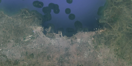
City subsidence using the example of Jakarta (Indonesia)
The main reasons for subsidence in megacities such as Jakarta are groundwater extraction related to urbanization and population growth, and steadily rising sea levels triggered by climate change. In addition, coastal cities often suffer from greater natural land erosion because they are built on soft soils such as clay and peat.
Besides the risk to humans, land subsidence also causes major economic losses such as structural damage and high maintenance costs for roads, railways, dikes, pipelines, and buildings.
Until now, monitoring megacities with GNSS monitoring was almost impossible due to the large distances between the base, which has to be located outside the cities on terrain not affected by subsidence, and the rovers inside the city. Thanks to HAPPY MONITORING, accurate subsidence results can now be provided throughout the city mm. These accurate elevation changes, along with many other measurements from geotechnical sensors, provide the experts with the basis for their assessments and help governments make more reliable long-term decisions.
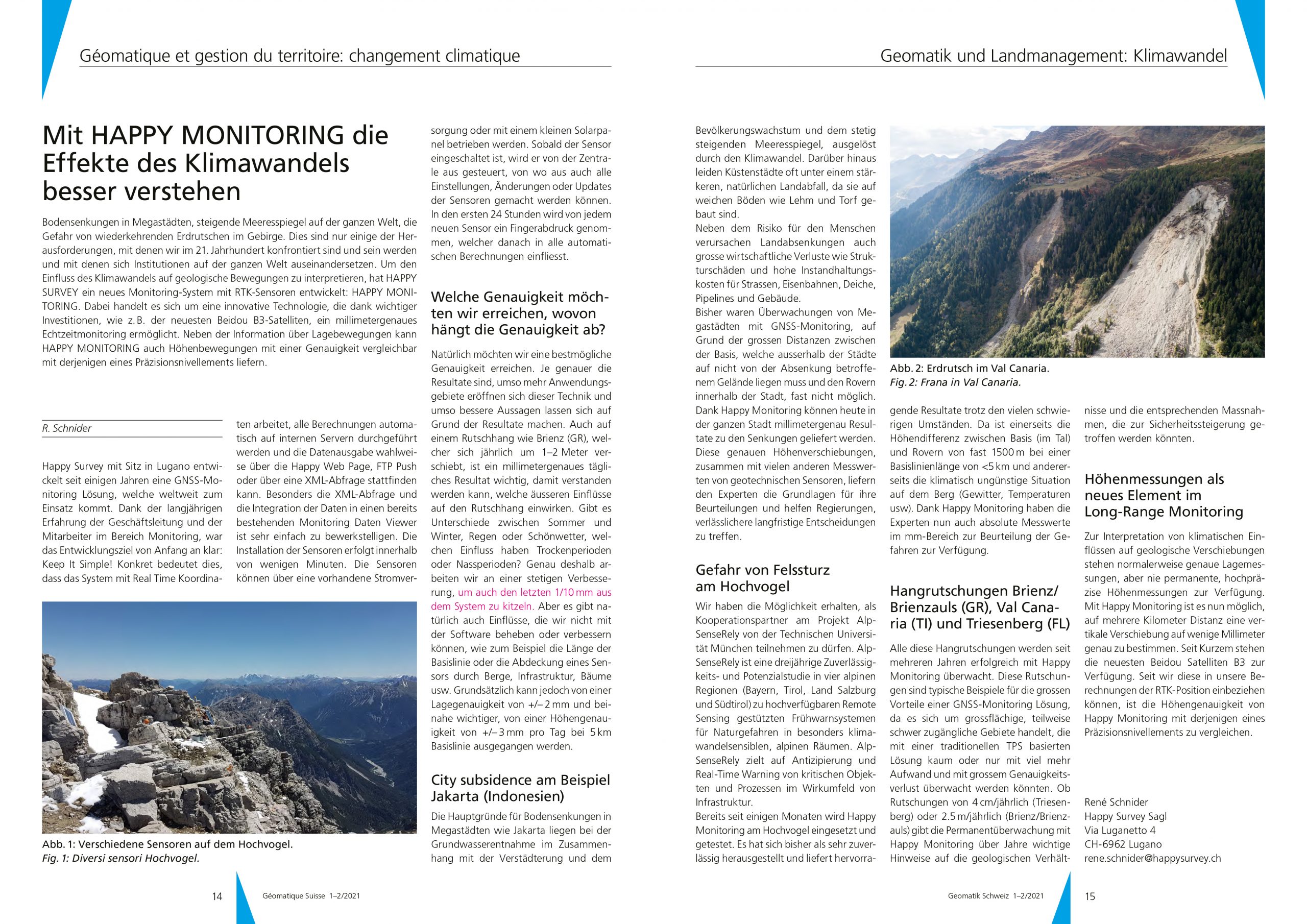
Danger of rockfall on the Hochvogel
We have been given the opportunity to participate as a cooperation partner in the AlpSenseRely project of the Technical University of Munich. AlpSenseRely is a three-year reliability and potential study in 4 alpine regions (Bavaria, Tyrol, Salzburg, and South Tyrol) on highly available remote sensing-based early warning systems for natural hazards in alpine areas that are particularly sensitive to climate change. AlpSenseRely is focused on anticipation and real-time warning of critical objects and processes in the impact environment of infrastructure.
HAPPY MONITORING has already been used and tested on the Hochvogel for several months. So far, it has proven to be very reliable and can deliver excellent results despite the many difficult circumstances, on the one hand the height difference between the base (in the valley) and the rovers of almost 1500m with a baseline length of <5km and on the other hand the climatically unfavorable situation on the mountain (thunderstorms, temperatures, etc.). Thanks to HAPPY MONITORING, the experts now also have absolute measured values in the mm range to assess the hazards.
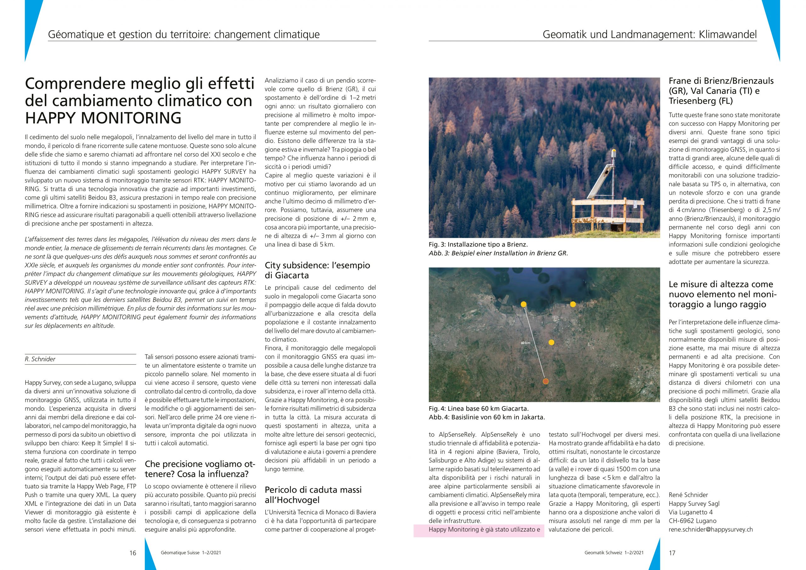
Landslides Brienz/Brienzauls (GR), Val Canaria (TI) and Triesenberg (FL)
All these landslides have been successfully monitored with HAPPY MONITORING for several years. These landslides are typical examples of the great advantages of a GNSS monitoring solution, as they are large areas, sometimes difficult to access, which could hardly be monitored with a traditional TPS-based solution, or only with much more effort and a great loss of accuracy. Whether landslides of 4cm/year (Triesenberg) or 2.5m/year (Brienz/Brienzauls), permanent monitoring over years with HAPPY MONITORING gives important indications of the geological conditions and the respective measures that could be taken to increase safety.
Height measurements as a new element in long-range monitoring
To interpret climatic influences on geological shifts, precise position measurements are usually available, but never permanent, high-precision height measurements. With HAPPY MONITORING it is now possible to determine a vertical displacement to within a few millimetres at a distance of several kilometers. Recently, the latest Beidou satellites B3 have become available. Since we can include them in our RTK position calculations, the height accuracy of HAPPY MONITORING is comparable to that of a precision levelling.
Related Posts

HAPPY MONITORING Germany enhances safety on Deutsche Bahn railways with HAPPY COLIBRI II
In a groundbreaking move at the end of 2023, HAPPY MONITORING Germany has launched the HAPPY COLIBRI II sensor system. This compact device is uniquely capable of being installed…

Discover GNSS Innovations with René Schnider at Oman Sustainable Week – Muscat
Join us on April 20, 2024, at 2 p.m., for a compelling presentation by our technical director, René Schnider. Titled “The Crucial Geoinformation with HAPPY MONITORING Swiss…
Successful kick-off for the installation of over 1000 GNSS HAPPY MONITORING sensors in Indonesia
This year marked a significant milestone for the City Subsidence Monitoring Project in Indonesia, beginning with the successful installation of the first 20 HAPPY HAWK sensors by…